St. Veit an der Glan, Austria. Future trends.

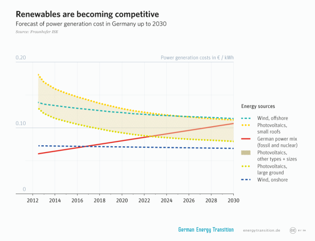
In future the city should expand the production of renewable energies. In the surrounding area of the city there is a lot of water. Therefore the city of St. Veit should try to focus additionally on water energy, and not just on solar energy. In the mountains the government of the city could built storage power station of water or hydraulic power stations in the rivers. This would improve their power on international markets, especially in the Alps-Adratic Region.

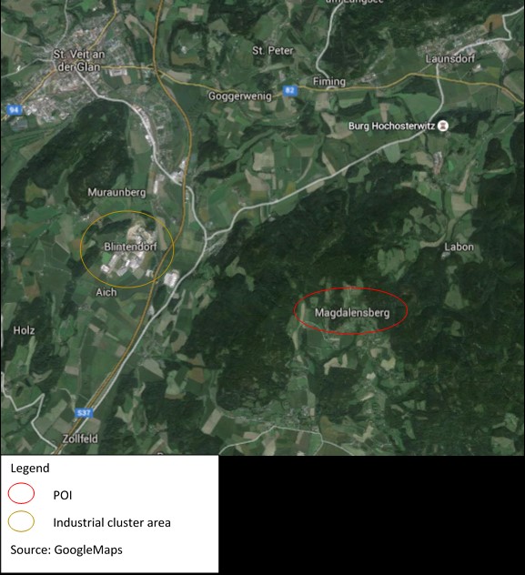
Furthermore, the industrial cluster area could be extended to ensure the city as an high-tec location. As an result, other international companies will possibly settle there. In addition, the location can once establish to a ‘little Sillicon Valley’. This development could solve the problem of brain drain, too. However, this is very unlikely for St. Veit because the suitable infrastructure is missing in the city.

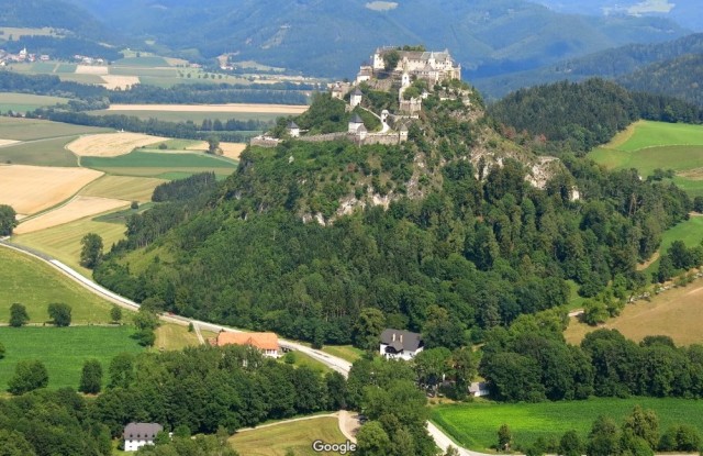
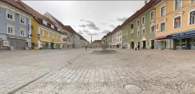
The tourism must focus on a nature-based development to maintain its currently good standard. In this development I see the biggest capability for the city and the surrounding area. Local farmer could establish a second main stay beside the agriculture. In a society where, compared to our modern stressful life, the tourism on a farm shows a real opposite. At the end of a valley they probably have no internet and in cases of great thundersturms, farmers could have no electricity for days.


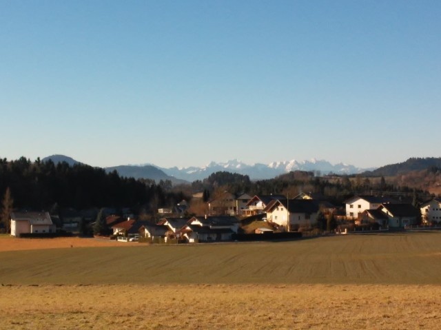
To understand the urban sprawl in a better way, it is important to know that Austria was a monarchy for a long time. In this periode it was common that landowners had big seigneuries. These include forests, fields, gardens and of course a huge residence of the landlord. In order of that, decentralised settlement pattern were appropriate. This was the basis for the later urban sprawl.

Nowadays, especially alpine farmers have huge areas of fields, grasslands and forests. The young generation does not want to keep the farm upright. Therefore, the image of a landscape is endangered. The landscape in the mountains is categorised into nativeness, (bio-)diverity, uniqueness and harmony. The categories qualify the human impacts in nature. It is describing the resilience of a place which shows how long and strong humans can affect an object without an irreversible change of main features.

Rural_Area_of_St.Veit3.jpg
Rural Area of St. Veit

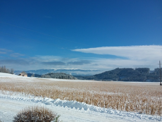
That means farmers have sheep, goats and cows or they cutting tress in different kinds of intenstity. If there is no little cultivation anymore in these days, the forests would extend and there would be a monoculture of tress, especially firs, all over the mountains. This would also destroy the rural landscape in this areas. Because of this it is important to keep some population in the mountains upright. This also justify a decentralised settlement pattern in the mountains.

For more information you can visit my website: https://ersmarioword.wordpress.com/

Sevilla: Mobility in a historical city. Future trends

One of EU goals’ for 2030 is to reduce GHG emissions, and transport is one the largest generator of them (EEA).  But we have to understand that urban sustainability is more of a process tan a goal and we have to be able to recognize urban areas as systems and not at individual items. For that policies must be adapted to meet the evolving challenges. Is Sevilla ready for that?

TH_2_544

Source: debatingeurope.eu

In order to give a concrete answer to the increasing mobility needs we have to be prepared and develop an integral mobility system, because most attractive cities are those who privilege walking, cycling and public transport. The Urban Planning Office of the city Council of Sevilla in cooperation with other departments at regional and national level,  the stakeholders and citizens have to be together in this process and increase the focus on city planning and densification problems.

To try to solve these problems I create a new blog where I will (attempt) answer these and othe mobility questions. If you are interested, please do not hesitate to visit and comment, I am glad to hear about new topics, new experiences and other study cases.

https://mobilitytrendsblog.wordpress.com/


And do not forget, MOVE YOURSELF!

Source: http://lacriaturacreativa.com/2014/05/una-colorida-campana-grafica-para-mostrar-los-beneficios-de-usar-la-bicicleta/


Sevilla, Spain: mobility in a historical city

Transport is one of the key areas where cities have a direct ability to influence the choices that residents make in how they commute.  Sustainable transport planning is very important in order to design the city structure and define which kind of city model residents will live in. According to the European Union Report European Transport Policy and Sustainable Mobility(1),  sustainable mobility actives travel modes, with more health and environmental benefits, offering a better quality of life and improves accessibility. In the case of my hometown, Sevilla has investmented in cycling networks together with a subway line and changed the commuting system and improved the image of the city.

But, where is Sevilla? And why the city development in mobility issues has been so successful?  Sevilla is the city where I was born. It is part of my childhood and my youth. Sevilla has personality, it is loud (in the Feria de Abril), serious (in the Semana Santa), it is colorful (in spring), charismatic, traditional and modern at the same time. It is a combination difficult to find in other parts of the world.

Sevilla is the capital of the province with the same name. It is the fourth largest city in Spain (after Madrid, Barcelona and Valencia).  It is located in southern Spain, in Andalucía, on the east bank of the Guadalquivir River. Starting with the Tartessians, then the Carthaginians and the Romans, later the Almohads until 1248, Sevilla has a multicultural background. Sevilla had the control of the trade with the American Colonies for almost 300 years, but then an economic crisis began. The civil war and the dictatorship of Franco slowed down the development of the city. In 1975 with the return to democracy, new perspectives were possible and with the EXPO 92, Sevilla started to think which kind of city it wanted to be. New highways, the Spanish High Speed Rail System (AVE) and in the last years the subway construction has changed the mobility patterns of the city.

Sevilla has transformed itself into a cycling city, in 2006 the construction started with 12 km, now the bike lanes have a length of 243,8 km, 138 km in the city, and 105,8 km in the metropolitan area. The plan is to build 205,6 km more for the metropolitan area in the next years. Almost 15% of the diary travels are done by bike (72,000 travels) and 20 % by public transport(2).

This bike lane investment was made also with a rent bike service SEVici, is a service from the company JCDecaux that has this contract until 2016.  I means that they have 544 publicity locations in the city and in return they are responsible for the installations, management and maintenance of 2.600 bicycles. Bikes are available 24 hours a day and the year season ticket is 33,33 Euros (36 $).

For all of that, Sevilla has suffered a major transformation in the last years. Sevilla is in the top 10 of the bicycle-friendly cities of Europe, and in less than ten years(3), the city has become the cycling capital of southern Europe(4).


(1) Mobility.eu

(2) bicicletas.us.es

(3) Theguardian.com

(4) Coppenhagenize Index


Salamanca, Mexico: Effective air quality management as an opportunity to accelerate sustainable growth

Salamanca is a municipality located in the state of Guanajuato,Mexico. It is situated at 1720m (5,643 ft) above sea level with a semi-warm and slightly humid climate, its average annual temperature is 18°C (64.4°F). Both its water and air resources are shared with neighboring municipalities.

Before the Spanish conquest, the area was inhabited by indigenous Otomi people. It´s urbanization started in 1603 when it was recognized as the town of Salamanca, taking the name from viceroy Gaspar Zuñiga´s hometown in Spain. However, the territory for towns in Mexico was not delineated very well, and in 1821 Mexico gained its independence and in 1910 the national revolution advocated for land reform and equal rights under the slogan “land and liberty”. In 1917 a new national constitution was officially recognized that gave public management responsibilities to municipalities.

This is relevant because municipalities in Mexico hold the power to lead the development of cities and the fulfillment of the population´s most basic needs: housing, waste management, air quality monitoring, local industry regulation, and other public services. Although municipal governments have to work closely with subnational and national governments, they are accountable for local zoning which, when not appropriately designed or implemented, can give rise to problems with rapid industrialization and urbanization. It is important to stress that until very recently municipal governments in Mexico could only be in office for a maximum period of three years, so usually political will or decision making is not guided by long term environmental or social justice initiatives in the framework of sustainability, but by short term objectives often focused on economic issues.

Currently both new industrialization and urbanization are themes of concern for Salamanca. Economic activity has been driven by industry even when agriculture also plays an important role. Since its establishment in 1950, the petroleum refinery RIAMA has mostly shaped Salamanca´s identity and the life of its inhabitants who were approximately 261,000 in 2010. The refinery is controlled by the national oil company Pemex, and it took around 10 years to gain the political will to implement the technological changes that allowed air pollutants emissions to be reduced to acceptable levels for public health.

Salamanca is now recognized as a leading city for air quality management in the country, but there is still a lot to do to ensure clean air for residents. Since 2013, the Japanese auto company Mazda installed assembly plants in Salamanca and Toyota is planning to build facilities, as well. This development brings a new wave of economic growth, including shopping malls, hotels, housing, and business tourism that often comes at the cost of environmental quality.

In the face of this development, environmental managers have to make their ideas heard and advocate for real and monitored sustainable development. Air quality managers, since air touches every other sector including public health, should be playing a major role in redefining what progress means for the city of Salamanca and the State of Guanajuato to be a leader for the nation.

Read more about this issue in: Trying for fertile ideas


Munich and its role in a transforming environment

The German energy shift and its implications for Munich

In the course of the German energy shift, the lack of renewable energy supply in the south of Germany will be partly compensated through the transportation of renewable energy from the northern parts of Germany to the south. But if Germany doesn’t succeed in expanding the energy system grid to transport the renewable energy from the north of Germany to the south, the certainty of the energy supply cannot be granted in Munich anymore. As a result Munich could lose its status as the economical pioneer region in Germany. The consequences would be: 1) increase of unemployment, 2) shrinking revenues of business taxes and 3) degradation of the infrastructural basis and loss of the innovational potential in the region. The whole status of Munich and its self-conception would be threatened by such a development.

Due to that scenario traditional values and identities will have to change. Traditional alliances will be rethought and new networks formed in politics and in society. This situation shows how the conflict about new resources leads to the breaking up of traditions and identities and encourages new partnerships. Therefore new perspectives are taken into account to find a satisfying solution. In this case a transformation of identity and traditions will be advantageous and therefore hopefully desired by the inhabitants and its responsible decision makers.

For more information on the German energy transition please see this paper of the Heinrich Böll foundation about the key findings of the German “Energiewende”. The Heinrich Böll Foundation is a catalyst for green visions and projects, a think tank for policy reform, and an international network.

Video. Explanation of the German energy transition

Future outlook for 2025

To keep its status as the culturally and economically most dynamic region in Germany, Munich will have to adapt all its opportunities which it already has gained from its current position. To act independently in the future, Munich has to decentralize the energy production from other regions and first use its own potentials (see White Paper for more information). After all of the own potentials are exhausted, Munich will have to start using the existing energy sources from other regions.

Munich is located in a very advantageous geological place. Deep under the surface of the city an enormous storage of heated water is embedded in the lime brick layers of the malm rock. The lime brick layers are porous and the cracks and pores of the layers are filled with natural thermal water which adopt the surrounding temperature of the rocks. The deeper the rock layers are, the higher is the temperature of the surrounding rocks and the higher is the temperature of the thermal water. In a depth of 2.000 to 3.000 meters the thermal water in the region of Munich reaches temperature of up to 100 degree Celsius, which is more than enough to use the water as a geothermal resource for an environmental friendly heat supply. The local public utility company “SWM” declared to make Munich the first German metropole to have a 100 per cent renewable heat supply system. Therefore by 2025 the company wants to build 5 new geothermal power plants in the region of Munich. Yet Munich has all the ideal conditions to accomplish this goal: an excellent geological underground and an existing modern district heating network.

For further information on the topic of geothermical energy resources in Munich please visit the attached simulation and click “start”: Simulation for geothermical energy use in Munich. (Unfortunately only available in German)

In terms of the heat supply Munich already paved the way for a sustainable and successful future, but in terms of the energy supply there is a lack of implementation of the needed energy grids. With the signing of the Climate Agreement from Paris the pressure on the conservative government in Bavaria is growing to pay for establishing the much needed energy grids to advance the energy transformation. The government in Munich as well as the population in Bavaria has to open up to make the desired transformation possible. Despite all the external pressure, the Bavarian government in Munich will react very slowly due to internal power relationships. The conservative government can be sure of a very stable majority in the parliament. Many people in Bavaria have the opinion that the governing party is the only political institution which can and wants to secure the cultural heritage of Bavaria. Nevertheless the governing party will block the plans for a new energy grid from the North of Germany to the South. As long as this situation doesn’t change, the German energy transformation will not be successful. Therefore there has to be a change in the political landscape of Bavaria or, because this is not likely to happen, the governing party will have to rethink its position.

GET_1A2_renewables_becoming_competitive_l

Due to these reasons I am convinced that Munich will successfully perform its transition from a fossil fueled past to a future with renewable energies. But the transition won’t happen fast enough. Due to the blocking position of the governing party the establishing of the new energy grid will be delayed and this will have a negative impact on the supply security. This will cause a stronger fluctuation of companies in the Munich region and therefore raising the willingness to pay for the governing party. In the end the governing party in Munich will be forced to change its attitude and initiate the establishing of the needed energy grids. But the transition will take place under worse conditions (time pressure) and therefore produce higher costs and lower acceptance in the population, which will make it more difficult for the planners to develop the most efficient strategy for the transition.

For more information and for experiecing other perspectives on the topic please visit the WordPress Site munichtransformation.wordpress.com


Vienna, Austria’s Donauinsel

The Danube Island (german: „Donauinsel“) is a narrow Island in Vienna (capital of Austria). It is located on the river Danube, which contains a vast riparian forest, with its excavated channel New Danube (“Neue Donau”), and has a length of around 20km. Additionally it splits Vienna into two parts. It is one of the world biggest artificial islands with around 4km².

In 1870, the year of the first Danube regulation, the Danube became a main channel with dams, flood areas and several branches. Unfortunately planers underestimated the need of flood protection and a terrible flood in 1954 destroyed a lot of infrastructure, even industrial areas. Due to that event the government decided to create a river regulation.
The main idea was to dig out the flood-prone area and create with the soil an artificial island, with the major function as a dam. This has positive influences to the water quality. In addition the city acquired areas of land that lost their function for flood protection because there was no flood any more. The government took this unique opportunity to grow the city closer to its traditional centre. So the two districts on the other riverbank got new sites for their growth.

Environmentally it was a really hard change in a local habitat of the floodplain. So the full area was recreated. Partially they used the soil for the creation of the Danube Island. The rest became building zone for urban planning, because of the need of such a kind of land for protective use. Hence the discussion about the real use of the Danube Island needed a long time, 25 years from the beginning to the official opening. In addition the effective surface wasn’t clear for a long period during the planning time. So planners changed the area completely for the possibility of a natural habitat to compensate the intervention into the habitat of the Danube. Due to those planning ideas the Tritonwasser was changed to a huge aquatic ecosystem, which is an essential place for rare flora and fauna. It also contains Death Ground (“Toter Grund”) which is a separated ancient branch of the Danube. Unfortunately local residents didn’t really accept the specific needs of a natural ecosystem and sometimes they left their cabbage and other trash and destroyed the natural heritage!

Despite new conflicts since the Danube Island was created, the influence of dominant plants are established in protected areas. This causes human impacts to guarantee a minimum conservation of natural areas. The Danube Island is a human masterpiece in water regulation, which is multifunctional and has important functions for social and natural welfare.

For further informations about the topic Danube Island see following link to its own wordpress site:

Introduction


Astana, Kazakstan – capital city and its contemporary environmental pollution problems

Astana became the capital of Kazakstan in December 1997 during the post-Soviet period of national reconstruction. It was chosen to be a capital due to its central location, territory, proximity to major economic centers of the country, demographic potential, and other socio-economic and environmental factors.

The city is located in the north-central Kazakhstan with the territory of 96,800 sq.km and population of 861,968 people (as of June 1, 2015). The local climate is sharply continental with summers characterized by dry, sandy winds with the high level of dust.

The location of Astana on Google maps:

The region has rich deposits of natural resources, which creates opportunities for active development of resource extraction, entrepreneurship, and international trade. The increased level of industrial activities combined with the increased load of urban transport led to high volumes of industrial emissions in the local atmosphere. These factors along with high natural inputs of dust particles currently pose serious environmental and health threats to the local population.

Major sources of industrial air pollution in the city can be divided into three groups: the stationary sources, transport, and fugitive emission sources. The leader among these sources of air pollution is transported, it accounts for more than 57% of total air emissions. Industrial and stationary sources are in second and third places respectively.

High levels of dust are another factor contributing to the city’s air pollution. Several years ago the concentration of dust in the city exceeded the maximum permissible level three times, and on some days, it reached 10-13 folds. The main sources of dust pollution are construction  sites, roads undergoing renovation, and streets and alleys that do not have a solid surface and storm sewer.

So what are potential solutions for the above-mentioned issues? Some of the means include:

Transport issue

City administration focuses on the development of transport infrastructure, construction, and roads repairment. Currently, the government is considering the implementation of a new transport system which envisions the use of light rail trams as an environmentally-friendly mode of transport. The goal is to relieve the traffic on the city streets and by this reduce air emissions. The reduction of transport congestion will also be secured by the construction of the main road which includes two overpasses over the railway line, three transport interchanges, and three bridges. After the completion of the road, the transport traffic which involves about 10,000 vehicles will clear the central parts of the city.

Natural dust issue

To reduce dust pollution, from 2005-2009 the reconstruction of old ash collectors was made with replacement to the installations of “emulsification“ on several central boilers. A similar system was implemented on some suburban active boilers. The current effect so far is positive: the concentration of ash in the air emissions decreased by 6-7 times along with an increase of sulfur oxides catchment rate by 3-4 times. In addition, the reconstruction of the historical part of the city is carried out with the demolition of the dilapidated housing along with the creation of new urban-architectural sites, and revitalization of the embankment. However, the issue still remains significant since according to statistics the amount of dust in the urban atmosphere is still exceeding the required level.

 “Greening“ measures of city

To alleviate the negative impact of industrial activities in the city, the certain procedures are in progress. Greening questions of the urban area occupies a special place among the environmental tasks of city administration. This is due to the fact that green spaces are an integral part of the planning structure of the city as they carry out a number of important functions in the environment, which greatly increases their ecological value.

The greening process of Astana is conducted in accordance with the Master plan of the administration. Its concept is to form “Eco-City“, the harmonization of urbanization with nature, creating the comfortable environment for residents.  Thus, the task was determined to form “green corridors“, or in other words, the spatial array of community gardens.

The main components of the system are the major park zones, the main green corridor and smaller green corridors of different types all of which are connected. The lower order of landscaping structures are local green spots within neighborhoods, micro-districts, households, etc. Green zones have a block-lane configuration that is crossed by green corridors. It should be noted that urban greening plays an important role in the improvement of atmosphere conditions from anthropogenic emissions while reducing noise levels in the city and suppressing the development of pathogenic organisms dangerous to public health.

For more information about Astana, and it’s historical and contemporary environmental conditions, please visit my personal blog by the following link: https://abylaikhan90.wordpress.com/. After reading the blog, you could share your thoughts and opinions with me on this page.

“A city with two souls” Kazan, Russia

You can read more about “the city with two souls” Kazan on the website: https://senseofkazan.wordpress.com/ 

If cultures with different origins and religions live side-by-side, could they coexist and collaborate without conflicts and wars? At the same time could they save their national identity? These are two big questions for global society, and particularly for the Russian Federation. Russia is the largest country by area in the world. People of the Russian Federation all together are Russians, but actually there are more than 190 different nationalities, which belong to many religions.

At a distance of 800 kilometers to the East from Moscow is located the national Republic of Tatarstan. “Tatarstan” is derived from the name of the ethnic group, the Tatars, which have been living there since the 13th century. The capital of this Republic is Kazan – the city with a 1000-year history. Nowadays it is already 1,176,187 inhabitants. It is where the Asian East meets the Russian West, the population evenly divided between the Volga Tatars (47,6%) and Russians (48,6%). The Tatars are Sunni Muslims and the Russians are Eastern Orthodox Christians. Kazan’s multicultural and multireligious experience could be a very good example for many countries to learn to live productive and peaceful lives accepting the cultural diversity of their neighbors.


Kazan historically received a significant advantage for mutual understanding both with European as well as with the eastern people. Kazan is located in the center of the European part of Russia, and therefore Kazan residents are Europeans. With eastern countries they have the same religion – Islam, which is followed by the majority of inhabitants of Tatar nationality. Plus, Tatar language, which has Turkic basis, has a large number of Arab and Persian words. At the same time, the equal proportion of Russian people allows the place to be in harmony with the rest of the Russian Federation. This leads to probably the best regional external policy in Russia. As a result, in the last ten years Kazan was on the peak of its development and success. Kazan was the host city for the 2013 World Summer Universiade, in 2015 for the World Aquatics Championships, and in 2018 Kazan will host the FIFA World Cup. It is accompanied by major renovations of the city infrastructure, increasing the quality of life for residents. Kazan is one of the most innovative and ambitious cities in Russia. The residents of Kazan are very proud of their city. Their average level of satisfaction and happiness is higher than in neighbor regions.

Islam and Orthodox Christian Church are two pillars, which are the base and pride of local society. In the heart of the city – in Kazan Kremlin the great Annunciation Cathedral and majestic Qol-Şärif mosque stand together as a symbol of this alliance. The residents celebrate both Christian and Muslim holidays. There is no significant nationality conflict. We can see a big controversy within the current global situation. At the moment there are lots of religious conflicts, wars, acts of terrorism, and aggressive organizations around the world. But if we have such examples, as Kazan is, perhaps we can achieve the cultural and religious mutual understanding and harmony worldwide.

Contemporary Flood Problems in Bandung, Indonesia

Bandung is the third most populous city in Indonesia with 2.5 million people. It is the capital of West Java Province and an important center for business and economic activities for Indonesia. Bandung is located in the Bandung Basin that was a prehistoric lake around 55,000 years ago. It is one of the largest watersheds on the island of Java with annual precipitation up to 1,700 mm and provides abundant amounts of water for drinking and agriculture as expected in a tropical environment in close proximity to the equator. A historical report revealed that people have been living in Bandung for 6,000 years.

Dutch colonization since the 17th century marked a change of Bandung landscape, starting with The Great Post Road construction that passed through Bandung in 1786. Due to its close proximity with mountains, Bandung had fresh air and cool weather compared to Batavia (the old name of the Indonesian capital city, Jakarta), which was considered more crowded, had hot climate, and unhealthy as a living place. This is also one of the factors that attracted people from Batavia and other areas to come and settle in Bandung. Soon after Indonesia had their independence in 1945, Bandung held its position as one of the most important cities for Indonesia. By 1950s, Bandung already had an area of 8098 ha and the population increased rapidly from 40,000 in 1906 to nearly one million in 1961.

Due to rapid urbanization and industrialization, since the late of 20th century, Bandung has been facing a massive urban problem: floods. The massive groundwater extraction by textiles industries in Bandung caused significant land subsidence which aggravates the floods. Moreover, urbanization creates further problems, as indicated by the increase of slums areas and the lack of solid waste management. More crucially, due to poor attitude of local people regarding their waste, it is common that the waste ends up in rivers or drainage channels.

Due to concerns about limited industrial areas since the late 1990s, the city government has been trying to shift the economic policy towards the service sector, such as commerce and tourism. Furthermore, the completion of Cipularang Highway that connected the capital city Jakarta and Bandung in 2005 caused a rapid increase of tourists in Bandung, especially tourists from Jakarta.

Bandung offers a number of natural-based touristic spots in the northern part of the city, e.g. panoramic view, volcanic crater, hot springs and a tea garden. The increasing number of tourists in Bandung triggers other commercial sectors. Not only natural-based tourism, but also hotel, real estate, restaurant, and mall developments are rapidly growing. Between 1998 and 2008, the housing and commercial constructions have grown by 50%, while in contrast the catchment areas in the northern part of Bandung decrease by 60%. The rapid increase of commercial constructions and real estate developments cause more land conversion which eventually aggravate more floods.

To learn more about Bandung, its environmental history, places of interest, flood problems, current and suggested efforts to mitigate floods, and how Bandung in 2025 would look like, please see my website in the link below:

https://rioaryablog.wordpress.com

After reading the articles on my website, I will be happy if you could share your thoughts and opinion about Bandung with me.

Sankt Veit an der Glan, Austria

Embedded in the basin of Klagenfurt, in southern Austria, Sankt (St.) Veit is surrounded by lakes, smaller rivers, grassland, fields and mountains. St. Veit is situated on the northern edge of the basin.

In an interglacial period, the area of St. Veit was a tremendous sea called ‘Tethys’ (about 250 million years ago). Millions of years later, there was a large glacier in the Mesozoic age (248-144 million years ago). But when the ice was melting, different kinds of moraines formed basins, terraces and hills. So called kettle holes formed the lakes.

Considered economically, St. Veit has a long history. Three hundred years before Christ the most important resource was the ‘ferrum Noricum’ (iron of the Norican people). At that time this special iron was quite unique in Europe and because it was very strong, it was used for weapons like lances and blades. Thus a Celtic village was established on a hill called ‘Madgdalensberg’. The blast furnace was running 24 hours a day producing weapons and minting coins to facilitate economic exchange and trade networks.

Water has always been an important issue for St. Veit. In the surrounding area there are many clean rivers and a main river called ‘Glan’ crosses the city. All the rivers and lakes have drinkable water. In earlier times, people used the water of the river for their animals and fields. In St. Veit a marketplace was established where farmers also offered their products.

Nowadays St. Veit is making itself a leader by developing e-mobility for residents. The city has its own industrial estate for renewable energy. Since its foundation in the year 1996, the park has established as an important location for renewable energy in the Alps-Adriatic Region. This energy cluster focuses upon solar energy, photovoltaic, biogas and insulating material.

Urban sprawl in this region is the highest in Austria. This recent development puts pressure on agricultural lands and requires a major investment in infrastructure, including electricity, water, sewage, transportation and other services provided by the public and private sector. This also increases the ecological footprint of the place.

An immense loss for the region is the brain drain of educated youth. Many well educated high school students often study at universities in Vienna or Graz and do not return because they may be overqualified for the jobs available in local communities. This is a serious concern for the future vitality of the region that has no simple solution.

Last but not least, anoher main topic is the tourism of the city. The beautiful lakes and the snowy mountains offer people many opportunities for outdoor recreation activities like skiing in winter and mountain bike riding in summer and a fascinating landscape. Based on projected climate change this economic sector is endangered and local communities are beginning to focus on alternative tourism as a solution for economic development and to keep young people from leaving the places where they grew up and their families may have lived for centuries.

Map-St.Veit
Legend of St. Veit and surrounding area
Castle_of_Hochosterwitz
Castle of Hochosterwitz (strong fortress in the Middle Ages)
Castle_of_Hochosterwitz
Castle of Hochosterwitz (strong fortress in the Middle Ages)
Main_square_of_St.Veit
Main square of St. Veit
Rural_Area_of_St.Veit
Rural area of St. Veit (in the background the Karawanks are visible)
Rural_Area_of_St.Veit2
Rural area of St. Veit (lake with drinkable water in the foreground)
Rural_Area_of_St.Veit3.jpg
Rural area of St. Veit in winter